How can we help you?

Parks & Green Spaces

Part of Warndon Woodlands Local Nature Reserve 

This area of woodland was planted to form a corridor between the ancient Warndon and Tolladine Woods, but also includes some veteran trees and hedgerows.

Access: Pedestrian entrances on Plantation Drive, Grosmont Avenue, Carisbrooke Avenue, Caister Avenue, Harlech Close. 
Footpaths lead from Hillwood Meadow, Tolladine Wood and Warndon Wood (crossing Parsonage Way).
A cycle path crosses the site between Hastings Avenue and Plantation Drive 

Site Facilities: Waymarked trail, benches, surfaced footpaths, wheelchair accessible, cycle path, play area nearby

Open: Pedestrian access 24hrs. 

Dogs: Well behaved dogs welcome, please clear up after your dog using the bin provided. 

Habitat: Recent Secondary Woodland, Semi-natural grassland, Veteran trees, Scrub and bramble, Hedgerows

Notable Wildlife: Great Spotted Woodpecker, Cowslip

Other features: The remains of a holloway are visible towards the Parsonage Way roundabout   

Waymarked Trails 

Three trails wind their way through Warndon Woodlands Local Nature Reserve. 

The Badger Trail (about 2.5km) follows surfaced paths for the entire length of New Plantation, and returns by way of leafy footpaths and pavements winding through the nearby housing estate. You can then complete your walk with a circuit of Tolladine Wood.

Except for Tolladine Wood, this route is wheelchair accessible (with some slopes), but please note there is no dropped kerb when crossing Saltwood Avenue

The Buzzard Trail (about 2 km) leads through Warndon Wood, across Stock Coppice Fields to the North, crosses Parsonage Way to the Anglo-Saxon St. Nicholas' Church, and returns by way of Hillwood Meadow and New Plantation. This route includes steps, stiles and potentially muddy paths in Warndon Wood. 

pdf View a leaflet with a map of all the Warndon Woodlands trails (3.38 MB) .

Site Map

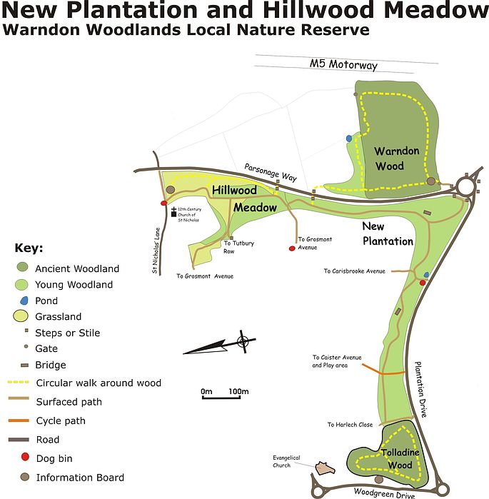
New Plantation and Hillwood Meadow site map

Management tasks include:

  • Thinning of semi-mature Ash plantation
  • Maintenance of furniture
  • Mowing of woodland glades
  • Footpath cutting
  • Hedgerow restoration

Part of Warndon Woodlands Local Nature Reserve

This area of grassland and young woodland is managed with wildflowers, butterflies and slow worms in mind. Different areas need different mowing techniques at different times of year. The area near Tutbury Row is cut in late summer, being richest in wildflowers, while the area near St. Nicholas Church is cut in the winter, when slow worms are dormant.

Access: Pedestrian entrances on St Nicholas' Lane, Grosmont Avenue, Tutbury Row.
Footpaths lead from New Plantation and Warndon Wood (crossing Parsonage Way).

Site Facilities: Waymarked trail, surfaced footpaths, information panel

Open: Pedestrian access 24hrs.

Dogs: Well behaved dogs welcome, please clear up after your dog using the bin provided.

Habitat: Recent Secondary Woodland, Unimproved grassland, Veteran Oak trees, Scrub and bramble, Wildflower grassland.

Notable Wildlife: Kestrel, Slow worm, Field vole, Marbled white butterfly.

Other features: Surfaced footpaths with some slopes. Next to the Anglo-Saxon St.Nicholas' church.

Waymarked Trails

Three trails wind their way through Warndon Woodlands Local Nature Reserve.

The Buzzard Trail (about 2 km) leads through Warndon Wood, across Stock Coppice Fields to the North, crosses Parsonage Way to the Anglo-Saxon St. Nicholas' Church, and returns by way of Hillwood Meadow and New Plantation. This route includes steps, stiles and potentially muddy paths in Warndon Wood.

pdf View a leaflet with a map of all the Warndon Woodlands trails (3.38 MB) .

Site Map

Map of New Plantation and Hillwood Meadow

Management tasks include:

  • Maintenance of furniture
  • Mowing of unimproved grassland
  • Footpath cutting
  • Slow worm surveys
Ronkswood Hill Meadows - Cows grazing
 
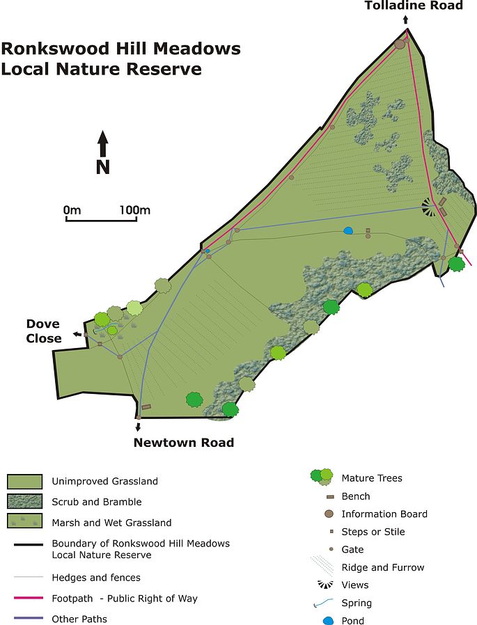
This is a pocket of traditional farming landscape in the City! Once part of the former Ronkswood Hill Farm, the Reserve is still grazed by cattle in the summer months, and 18th Century hedgerows have been restored. A patchwork of scrub and bramble and ponds add to the value of the site for biodiversity.

Access: Pedestrian entrances on Newtown Road, Tolladine Road, Dove Close 

Site Facilities: Views, benches, interpretation board

Open: Pedestrian access 24hrs

Dogs: Well behaved dogs welcome, please put your dog on a lead when cattle are on site.

Habitat: Unimproved grassland, Scrub, Hedgerows, Ponds

Notable Wildlife: Yellow Meadow Ant, Fox, Kestrel, Green Woodpecker

Other features: Earthwork remains of WW2 searchlight battery, ridge and furrow, views to Worcester Cathedral and Malvern Hills.

Site Map

Ronkswood Hill Meadows Local Nature Reserve Site Map

Management tasks include:

  • Grazing by cattle
  • Scrub clearance
  • Thistle topping
  • Maintenance of furniture
  • Footpath cutting
  • Hedgerow restoration
Perry Wood has a long and varied history, and has existed in some form since Anglo-Saxon times. Generations of people have influenced the character of the wood, with the importance of agriculture and forestry declining in the 20th century in favour of wildlife conservation and recreation. This ancient woodland with King's Field to the north became Perry Wood Local Nature Reserve in 1987.

Access: Several pedestrian entrances including Liverpool Road, Redfern Avenue Perry Wood Walk, Medway, Hillside Close, Canterbury Road.

Site Facilities: Views, parking (not WCC), waymarked trail, interpretation board, benches

Open: Pedestrian access 24hrs.

Dogs: Well behaved dogs welcome.

Habitat: Ancient Semi-Natural Woodland, Unimproved grassland, Scrub and bramble

Notable Wildlife: Buzzard, Jay, Bluebell, Speckled Wood Butterfly, Treecreeper, Ramsons

Other features: Several historic landscape features visible: ridge and furrow, wood banks, holloways. Views across Worcester. 

Site Map

Perry Wood Site Map

Perry Wood Trail

A new waymarked trail, funded by the Forestry Commission's Woodland Grant Scheme, was launched in January 2011. The trail leads visitors past many of the historical features of the wood, and gives a chance to discover the varied wildlife of the different habitats.

pdf Trail leaflet and Site Map (1.64 MB) .

 Management Tasks include:

  • Coppicing of hazel understory
  • Thinning of mature oaks
  • Footpath cutting
  • Maintenance of furniture
  • Selection and management of Veteran trees
  • Mowing of Unimproved grassland

Further Information

Numbers refer to the Site Map

Ancient Semi-Natural Woodland

In spring the ancient woodlands are awash with Bluebells, Ramsons and Wood Anemone, especially in coppiced areas. Coppicing means that we cut down the Hazel trees in a small area of the wood, and when the Hazel grows back, it has lots of small stems, instead of one large one. The mature Oak and Ash trees are left to grow on as "standards". Managing the wood in this traditional way means that there is always an area of the wood with lots of light, which some butterflies and flowers need to thrive. Purple and White-letter Hairstreak butterflies can be spotted at the edges of the coppice plots and the woodland glade (1).

Perry Wood was managed as "coppice with standards" between the 17th and late 19th centuries, and probably earlier. The Hazel was cut for firewood, hurdles and stakes for hedging then left to grow for around 10 years. Some of the Oaks and mature Ash would have been cut for building, when they were between 80 and 100 years old. We still use the Hazel for hedging stakes as well as repairing paths, but the main reason we cut it is because it's good for wildlife.

Sometimes we cut down mature Oaks, again to let in more light. If the timber is suitable, we use it for making furniture such as benches and information boards for the City's nature reserves. Some areas of the wood are left untouched, particularly the sloped western edge (2) where Hornbeam and Cherry are more common, and some trees are selected to become veterans, providing habitat for a host of specialised insects as well as nesting and feeding sites for birds. Look out for Greater Spotted Woodpeckers, Treecreepers, Nuthatches, Jays, Sparrowhawks and Buzzards.

In the past the Deer and livestock may have grazed in the wood, so it was common to surround a wood with a bank and ditch, possibly topped by a hedge or fence. On the northern edge of the wood (the oldest boundary) the surviving traditional bank and ditch (3) are still clearly visible today.

The boundaries of the wood have changed little since 1839, when 5 hectares of woodland to the southeast of the current wood (where the majority of Liverpool Road is now) was cleared for pasture. At the Marley Banks (6), a holloway created by centuries of passing feet and carts marks the southern boundary of the Reserve.

Grassland and Scrub

The "ridge and furrow" pattern (4) on Kings Field is at least 200 years old, and was formed by centuries of ploughing before the field was left to pasture, sometime before 1820.

While a large area of grass is cut short, at the edge of the field next to the woodland the grass is left long to allow the wildflowers and grasses to flower and set seed. This provides nectar sources for many insects, and in the summer this area is awash with Ringlet, Green-veined White, Meadow Brown and Orange Tip butterflies. Green Woodpeckers feed on ants in the open field, and the long grass gives shelter for Slow-worms and small mammals.

The trench (5) in King's Field may have been a holloway or a medieval quarry, and may have been used by parliamentary forces who had an encampment in the wood during the Battle of Worcester in 1651. A map of 1790 shows the position of "Cromwell's Oak".

The mixture of scrub and bramble in the trench and at the northern end of the reserve adds to the overall diversity of the site. Small tortoiseshell butterflies feed on bramble flowers, and the scrub provides nesting and breeding sites for a variety of woodland and garden birds.

This Reserve is made up of two wetland areas linked by the old Offerton Lane. It was created to provide a drainage balancing area to receive the rainwater run off from the surrounding industrial estate. The western end is dominated by a large pool, favoured by waterfowl. The reedbed at the more secluded eastern end is home to Reed and Sedge Warblers.

Access: Pedestrian and cycle access from Wainwright Road, Offerton Lane (no vehicle access), and Worcester and Birmingham Canal.

Site Facilities: Bench, viewing platform, cycle path

Open: Pedestrian and cycle access 24hrs.

Dogs: Well behaved dogs welcome.

Habitat: Wildflower grassland, Scrub, Hedgerows, Pond, Reedbed, Veteran trees

Notable Wildlife: Mute Swan, Mallard, Grey Heron, Reed Warbler, Reed Bunting, Dove's Foot Cranesbill, Rook, Buzzard, Field Rose.

Other features:  The nearby Worcester and Birmingham Canal provides a corridor for wildlife as well as transport and leisure opportunities for people.

Site Map

Map of Offerton Lane LNR

Management tasks include:

  • Mowing of Wildflower grassland
  • Scrub clearance
  • Ragwort control
  • Maintenance of furniture
  • Footpath cutting

Further Information:

What can you see there?

The western end is dominated by a wet balancing area in the form of a large pool, favoured by waterfowl such as mallard, moorhen and coot. Emperor, southern and common hawker dragonflies can be seen in season hunting for insects over the water and the pool environs.  

Bats are well represented on the site, with common and soprano pipistrelle, noctule and daubenton's bats using the varied habitats of the reserve. Grassland and scrub provide homes for butterflies, including the rare brown argus.

During the spring and summer month's chiffchaff, willow, reed and sedge warbler, blackcap and whitethroat can all be observed, in addition to the list of resident species that can be spotted all year round.

The eastern section comprises a dry balancing area which has developed into a reed bed of common reed (Phragmites) and reed mace. (Typha)

Reed is a scarce habitat in Worcester. Offerton lane is one of a tiny number of city sites to support reed bed specialist species such as reed, sedge, cetti's warblers and reed buntings. Kingfishers can be seen hunting fish fry within the open water channels in the reed, while herons are frequent visitors.

Mature hedgerows surround the reed bed providing a wealth of nesting and feeding opportunities for gold, green and bullfinch; the ripe fruits of field rose, hawthorn, crab apple and blackthorn attract flocks of redwing and fieldfare in the late autumn and winter. 

Small pockets of flower rich grassland around the reed fringe provide homes for peacock, orange tip, gatekeeper, meadow brown and ringlet butterflies, while dragonflies such as southern hawker and broad bodied chaser can be seen patrolling the paths and hedgerows.

The hedgerows and mature trees that surround the site not only filter out much of the road generated noise from the nearby A449, but also screen the visitor from the adjacent factory buildings. The resulting impression of natural charm and isolation belies its position within a busy industrial landscape.

What have we been doing there?

As part of an ongoing programme of management, we have periodically cut back some of the scrub on the western side of the site, to ensure that the open grassy areas are not lost.

The flower rich grassland is cut in late summer, once the seed is set and the butterfly species have completed their lifecycles. 

We have improved the drainage of the main surfaced path that connects Wainwright Rd to Offerton lane, and maintained the remaining network of routes around the reserve.

The Conservation team conduct regular bird and butterfly surveys on site and, a number of successful bat walk events with the general public have been conducted here.

Since 2002 we have, with the help of volunteers, cleared vegetation from the main pool, coppiced the scrub on the island and, at the eastern end of the site, laid 150m of hedge. Hedge laying has the effect of prolonging the life of the hawthorns and promoting new growth from ground level. 

This in turn allows field and dog rose, bramble and blackthorn to regenerate, adding their berries and fruits to the wealth of food provided by the hedgerow in autumn.

The photograph shows a 50m section of laid hedge after completion. The trees rapidly regenerate to form a food rich habitat for invertebrates and birds. The hedge will be ready to re-lay in eight to ten years.
Still can't find what you're looking for?

Contact us for help with services not available online.